


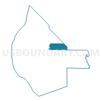
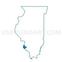
PRECINCT 7, Monroe County, Illinois
About
Outline

Summary
| Unique Area Identifier | 573626 |
| Name | PRECINCT 7 |
| County | Monroe County |
| State | Illinois |
| Area (square miles) | 10.94 |
| Land Area (square miles) | 10.83 |
| Water Area (square miles) | 0.11 |
| % of Land Area | 98.99 |
| % of Water Area | 1.01 |
| Latitude of the Internal Point | 38.32106820 |
| Longtitude of the Internal Point | -90.07875930 |
Maps

Graphs
Select a template below for downloading or customizing gragh for PRECINCT 7, Monroe County, Illinois


Neighbors
Neighoring Voting District (by Name) Neighboring Voting District on the Map
- MILLSTADT 3 Voting District, St. Clair County, IL
- PRAIRIE DU LONG Voting District, St. Clair County, IL
- PRECINCT 19, Monroe County, IL
- PRECINCT 26, Monroe County, IL
- PRECINCT 27, Monroe County, IL
- PRECINCT 28, Monroe County, IL
- PRECINCT 33, Monroe County, IL
- PRECINCT 6, Monroe County, IL
- PRECINCT 8, Monroe County, IL
Top 10 Neighboring County Subdivision (by Population) Neighboring County Subdivision on the Map
- Millstadt township, St. Clair County, IL (6,718)
- Prairie Du Long township, St. Clair County, IL (2,244)
- Precinct 27, Monroe County, IL (1,853)
- Precinct 26, Monroe County, IL (1,623)
- Precinct 8, Monroe County, IL (1,031)
- Precinct 6, Monroe County, IL (989)
- Precinct 28, Monroe County, IL (787)
- Precinct 19, Monroe County, IL (730)
- Precinct 7, Monroe County, IL (569)
- Precinct 33, Monroe County, IL (536)
Top 10 Neighboring Place (by Population) Neighboring Place on the Map
Top 10 Neighboring Elementary School District (by Population) Neighboring Elementary School District on the Map
Top 10 Neighboring Secondary School District (by Population) Neighboring Secondary School District on the Map
Top 10 Neighboring Unified School District (by Population) Neighboring Unified School District on the Map
- Waterloo Community Unit School District 5, IL (17,917)
- New Athens Community Unit School District 60, IL (3,983)
Top 10 Neighboring State Legislative District Lower Chamber (by Population) Neighboring State Legislative District Lower Chamber on the Map
Top 10 Neighboring State Legislative District Upper Chamber (by Population) Neighboring State Legislative District Upper Chamber on the Map
Top 10 Neighboring 111th Congressional District (by Population) Neighboring 111th Congressional District on the Map
Top 10 Neighboring Census Tract (by Population) Neighboring Census Tract on the Map
- Census Tract 6005.01, Monroe County, IL (6,888)
- Census Tract 5032.03, St. Clair County, IL (6,718)
- Census Tract 6004.01, Monroe County, IL (6,396)
- Census Tract 5040.01, St. Clair County, IL (4,901)